Amazon Deals

New at Amazon

Showing posts with label map. Show all posts

Friday, January 21, 2022

Map of power outages caused by squirrels, with bonus squirrel-related links

"I don't think paralysis [of the electrical grid] is more likely by cyberattack than by natural disaster. And frankly the number-one threat experienced to date by the US electrical grid is squirrels." 

~ John C. Inglis, Former Deputy Director, National Security Agency 2015.07.09

The war with the squirrels continues unabated - from Cyber Squirrel 1 (who is, unfortunately, no longer updating):
This map lists all unclassified Cyber Squirrel Operations that have been released to the public that we have been able to confirm. There are many more executed ops than displayed on this map however, those ops remain classified.
Screenshot from CyberSquirrel1

The data is gathered from Twitter and then listed on a filter-able Google map. You have the option to narrow the data by year and by month, and can even choose to only view the cases related to squirrels, non-squirrels, or all animals, including birds, raccoons, snakes and beavers. The interactive map is available here.

Related posts/links:

Video: The Narcoleptic Squirrel Song.

I'm pretty sure this flesh-eating-squirrels-because-fracking movie never got made, but if it ever happens, I'm in: Squirrels - Pre-production Sales Trailer.


A fire that heavily damaged an apartment complex was started by a resident using a propane torch to remove a squirrel's fur.

Scottish brewery releases $20,000 beer in taxidermy squirrel.

Friday, June 14, 2019

Friday links


Sunscreen Prevents Cancer, Right? Well, It’s Complicated.


“Kids, you tried your best and you failed miserably. The lesson is, never try.” - A selection of parenting advice from Homer Simpson:  Related: one of my favorite Father's Day stories (NSFW- language).

Physics: on the physical (im)possibility of lightsabers". Direct link to the PDF.


ICYMI, most recent links are here, and include urban and wilderness survival hacks, eating out in Victorian England, the photos on which classic pin-up girl paintings were based, and how Dr. Seuss changed education in America.

Tuesday, June 26, 2018

Tuesday links

The Swiss Army Survival Tampon: 7 Survival Uses. Related, from the same guy: 11 Ways A Condom Can Save Your Life.

Getting angry and flipping over a table: the supercut.

Interactive Map Shows Where Your House Would Have Been 750 Million Years Ago. Type in your address and use the drop-down arrow at the top of the page to chose how far back to go, or just use the up and down arrow keys.

As a recruiting tool, the U.S. Navy built a battleship in New York City's Union Square. It was there from 1917-1920.

The parakeet has a goiter: the best standard publisher rejection letter ever.


ICYMI, Friday's links are here, and include the birthday of Ambrose Bierce (author of The Devil's Dictionary), the history of state liquor laws, awkward pregnancy photos, Japanese spider fighting, and that time the U.S. released a bioweapon in San Francisco.

Wednesday, May 16, 2018

An Interactive Map Shows Just How Many Roads Actually Lead to Rome

Zoomable version here.

...he went away, and passing through what was called the house of Tiberius, went down into the forum, to where a gilded column stood, at which all the roads that intersect Italy terminate.

~ Plutarch, Life of Galba (XXIV.4)

All roads lead to Rome.

To illustrate, designers Benedikt Groß and Philipp Schmitt worked with digital geographer Raphael Reimann to select 486,713 starting points on a 26,503,452 km² grid of Europe. The image above is from their interactive map Roads to Rome - zoom in for detail.

Via Open Culture, where they also point out:
In a nod to map lovers outside of Europe, the mobility-obsessed team came up with another map, this one geared to stateside users.
Do you know which of the United States’ nine Romes you are closest to?
Now you do, from 312,719 distinct starting points.

Sunday, January 21, 2018

Animated map of the changing borders and population of Europe: every year since 400 BC

Animated European history - this video shows the borders and populations of each country in Europe, for every year since 400 BC. Vassal states and colonies are not included in the count of a country's population.

Watch full screen.


Sources : 1. Population :
- Angus Maddison (2003), Historical Statistic for the World Economy
- Colin McEvedy & Richard Jones (1978), Atlas of World Population History
- Tacitus.nu
2. Borders
- EmperorTigerstar - The History of Europe: Every Year
- EmperorTigerstar - The History of the Middle East: Every Year
- Ollie Bye - The History of Africa: Every Year
3. Music
- mrgice3 - Gladiator - The Battle Super Theme Song

Wednesday, October 4, 2017

Wednesday links

From 1803, the Ottoman Empire's first map of the newly minted United States


A Creepy Crawly Collection of Insects Built Out of LEGO.

Hormone Guide: How to Speak to Women.

A Natural History of the Wedding Dress.

Rodents of Unusual Size: Giant Rat That Fell From Sky Is New Species.

ICYMI, Friday's links are here, and include 1960 directions for building your own fallout shelter, why we yawn, organizing concerts in German prison camps, an octopus city, and what happens when you get beamed down in Star Trek.

Tuesday, May 30, 2017

A Map of Every Goat in the United States, with bonus goat-related links

At WaPo:
There were 2,621,514 goats in the United States as of 2012, the year of a recent USDA Agricultural Census. If America's goats were their own state, its population would be larger than that of Wyoming, Vermont, D.C. and North Dakota -- combined. This is what all those goats look like on a map.
America's goat population is heavily concentrated in the Southwest, Texas in particular. Nearly 80 percent of America's goats are raised for meat. Sixteen percent are raised for milk, with the remaining 6 percent is comprised of Angora goats raised for mohair.
You'll find commercial goat farms operating in 2,996 of the country's 3,143 counties. Of the top ten goat-producing counties, 8 are in Texas and two are in Arizona. In Sutton County, Texas, goats outnumber people 14-to-1. In Edwards County, also in Texas, the ratio is 22-to-1. All in all, goats outnumber people in 21 U.S. counties, all but one of which are in Texas. 
And, because no post about goats is complete without it, here's the supercut of goats yelling like humans (Turn the sound down but not off):


Pelated posts and links:

Here are goats singing the US national anthem.

Apparently "Goat Arousal Expert" is a real job.

The Obama administration put in place new goatherder regulations to assist foreign workers who fill goat herding positions in the U.S.


Tree-Climbing Goats Scatter Seeds By Spitting.

Thursday, April 6, 2017

Thursday links


These 10 companies control everything (edible) that you buy

In 1650, here's how you could dye your hair blond.

Map: watch as the world’s cities appear one-by-one over 6,000 years.

Victorian ‘Coffin Torpedoes’ Blasted Would-Be Grave Robbers.

ICYMI, Friday's links are here, and are all April Fool's Day related: history, pranks, and hoaxes.

Monday, March 6, 2017

Map of where Germans voted for the Nazis in 1933

In March 1933, a unified Germany held its last relatively free election before WWII. Hitler had already become Chancellor but he held one last election, seeking a mandate under which to rule. This map shows which areas of Germany supported the Nazi Party most strongly.


However, it’s also important to note that while the Nazis won the most seats in 1933, they did not win a majority of them or the popular vote.

Support varied widely across the country. It was highest in the former Prussian territories in the north-east of Germany (with the exception of Berlin) and much weaker in the west and south of the country, which had, up until 1871, been independent German states.

Across Germany as a whole, the Nazis won 43.91% of the popular vote and got 44.51% of the seats. This made them by far the largest party in the German Reichstag, but still without a clear majority mandate.

via Kottke

Wednesday, December 14, 2016

Wednesday links

Lots of ugly Christmas sweaters, instructions for making your own, plus ugly Christmas sweater suits, and here's how to make Ugly Sweater Ornaments.

CIA Declassifies Maps from 75 Years of Surveillance.


T'was the Overnight Before Christmas: The Merry Tale of How Air Cargo Deregulation Led To Amazon. Related (by the underlying poem): T'was the Night Before Kwanzza, and more of Kathy Shaidle's Kwanzaa-debunking collection


ICYMI, Monday's links are here, and include Mother Teresa's meeting with then-NYC Mayor Guliani to lobby for a parking permit, the pre-Seinfeld origins of Festivus, Teddy Roosevelt's impact of football, and a new Guinness World Record-setting Rube Goldberg machine that takes 412 steps to light a Christmas tree.

Sunday, October 2, 2016

These maps show how the continents would look if you could see gravity


Precisely measuring Earth's gravity is surprisingly difficult - we know how strong it is in general, but the force of our planet's pull varies significantly from one part of the planet to another, and detailed maps of that pull offer significant clues to what lies under Earth's surface, not to mention critical information for architects and engineers.

Some of the best maps of Earth's gravity come from the Western Australian Geodesy Group at Curtin University. Geodesy is the mathematical study of Earth's shape and properties. The group combined data from satellites and Earth-bound observation to produce the highest-resolution maps of the planet's gravity ever made. The result: maps of six of Earth's continents by local gravity.

Here's what they look like in North America. Blue regions have lower gravity, while red regions have higher gravity:


See the rest of the continents here: These maps reveal how Earth would look if you could see gravity

Wednesday, September 14, 2016

Wednesday links


How many fireflies would it take to match the brightness of the Sun?

The designated survivor: while most government officials are at the State of the Union address, one member of the Cabinet is flown to a secure location in the event that the Capitol is attacked and the entire government is wiped out.

Which body part hurts the most when stung by a bee? A scientist put himself through a torturous experiment to find out.

The discovery and reconstruction of a Supermarine Spitfire.

The Illustrated Map of America's Worst Utopias.

ICYMI, Monday's links are here, and include how far above and below your property you own, a fall foliage prediction map, how a bean becomes a fart, and H. L. Mencken's birthday.

Monday, June 6, 2016

Monday links

Today is the anniversary of D-Day: quotes (Shakespeare, Eisenhower, Churchill), videos (footage, FDR's and Reagan's speeches), lots of links. Related: The Gear, Gadgets and Weaponry of a D-Day Paratrooper.


Town installs giant inflatable turd to deter bad dog owners.


Railguns: A First Look at America’s Supergun.


ICYMI, Friday's links are here, and include the anniversary of the evacuation of Dunkirk, the 1909 Cherry Mine disaster, the NSA's exceedingly weird guide to the internet, and Goat Trauma Awareness Month.

Friday, May 27, 2016

Map of each state’s favorite Google question

Via Estately:
Using Google Autocomplete we compiled hundreds of the most common questions Americans type into the Google search bar. We ran those searches through Google Trends to determine which state queried each of these selected searches the most over the past 12 years. To be clear, the list below does not represent what each state Googles the most, it simply shows the searches each state Googles more frequently than the other 49 states and the District of Columbia.
For example, there are questions Alaskans ask more than “How to smoke salmon?”—but they ask that one a lot more often than the lower 49.


The few below jumped out at me, but the whole list is available here.

Georgia: "Why are my nipples so sore?"

South Dakota: “Why is my poop green?”

Michigan:  “Is Mr. T dead?”

Kansas: “How to make meth?”

California: “Is Bernie Sanders vegan?”

Kentucky asks, “How to make a baby?”

Arkansas: "Who won the Civil War?"

Wednesday, March 23, 2016

Wednesday links

Happy Purim: Here's the SNL skit where Gilda Radner explains that she saves up all of her orgasms for this day.

Movie Scenes Before And After The Special Effects Were Added.

Sure, Superman Has X-Ray Vision. But How Would It Actually Work?


ICYMI, Tuesday's links are here, and include William Shatner's 85th birthday, why your nose runs when it's cold, explaining the Italian/New Jersey accent, and a baby elephant try to figure out how his trunk works.

Thursday, March 10, 2016

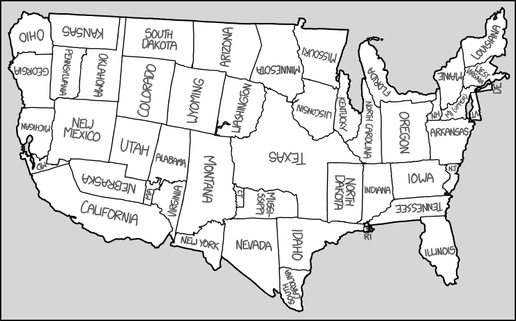
Map of the United Repositioned States

Randall Munroe rearranged the states without compromising the general shape of the U.S.:


I highly recommend Munroe's books - I've given out several and they're consistently a big hit.

Wednesday, January 27, 2016

Generic map of Every City

It's rather astonishing how similar all cities are, when you come right down to it.

We travel the globe to marvel at the world's diversity; but we dare not ask ourselves the question that negates the time and money we spent to get there: Why does every place look so much like any other place?
All high streets and shopping malls are slightly rearranged versions of each other. Cities have rich and poor areas; big cities have financial quarters and ethnic neighborhoods. All cities have clogged traffic arteries, post-industrial pockets of hipness, and districts that hate each other's guts for no other reason than that they're across the river from each other, or on opposite sides of the tracks.


H/T Dyspepsia Generation

Monday, May 4, 2015

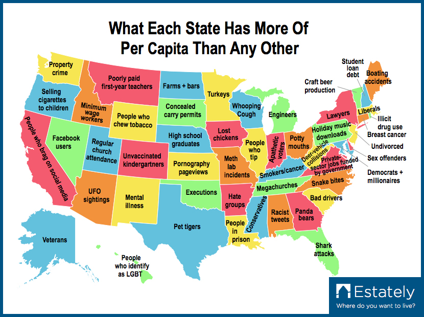
Map: What Does Each State Have More Of (Per Capita) Than Any Other?

Not surprisingly, here in Virginia we have more private sector jobs dependent on federal contracts than anywhere else - we benefit from DC's increasing sucking of all the resources out of the provinces. 


Click here to embiggen

via Daily of the Day

Friday, April 3, 2015

Friday links

What happens when you crack your knuckles, including the researcher who cracked the knuckles in one hand only for over 60 years to see if he'd get arthritis.


New Zealanders Celebrate Easter by Shooting Bunnies.

Easter cards from The Onion.

Elementary school takes Easter out of egg hunt (because bunnies are too religious), plus the Seattle school that renamed Easter eggs 'Spring Spheres'.

10 DIY Ways to Decorate Your Easter Eggs.

Video: Dogs Train Their Human Friends to Keep Petting Them.

Late 19th-Century Maps Show Measles Mortality Before Vaccines.

Engineering students extinguish fire with sound.

ICYMI, Tuesday's links are here, and are all April Fool's Day and/or hoax related.